Rider Info

Service Updates

Jump to route schedules.


See how route timing is impacted, or check your bus location on iTransitNW.

Vea cómo se ve afectado el tiempo de la ruta o verifique la ubicación de su autobús en iTransitNW.


Service Changes

All services have returned to regular hours as listed on the website. Some routes remain impacted by local construction; please pay close attention to this page’s short-term and long-term deviation sections to stay informed of changes to your route. If you have questions please call 509-525-9140.


Dial-a-Ride Service Changes Coming in 2027

Beginning in January 2027, the Dial-a-Ride service area will be expanded to include additional neighborhoods.

Current Dial-a-Ride Boundaries (in 2026)
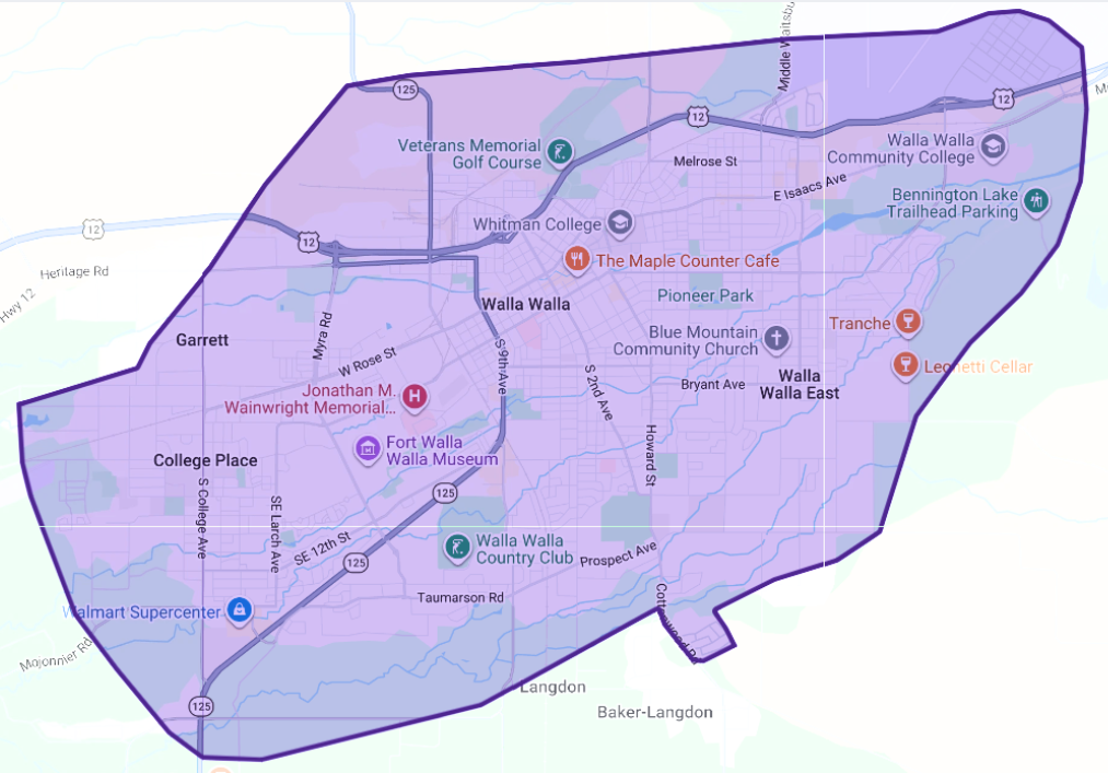
Map of the Walla Walla area with a large, irregular purple-outlined boundary and transparent purple shading. The boundary includes central Walla Walla, College Place, Walla Walla East, Whitman College, Walla Walla Community College, the Veterans Memorial Golf Course, Walla Walla Country Club, and nearby neighborhoods. The map uses a darker, higher-contrast purple outline and overlay while retaining visible streets and landmarks.

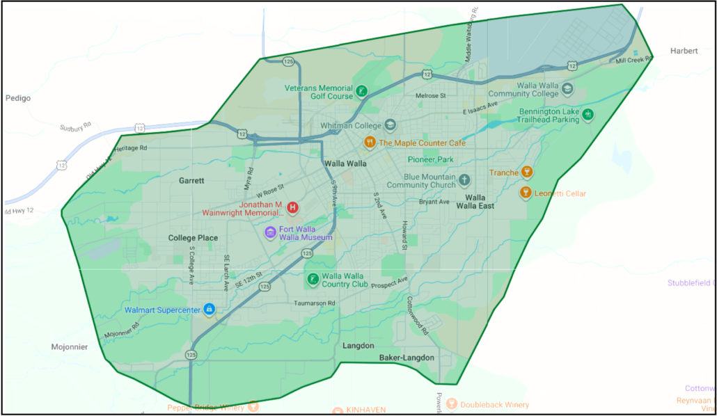
New Dial-a-Ride Boundaries (in 2027)

Map of the Walla Walla area with a large, irregular green-outlined boundary and transparent green shading. The boundary includes most of Walla Walla, College Place, Walla Walla East, Whitman College, Walla Walla Community College, the Veterans Memorial Golf Course, Walla Walla Country Club, and nearby neighborhoods. Major roads, parks, schools, businesses, and landmarks remain visible beneath the green overlay.

The purple map shows the current service area. The green map shows the expanded service area. The expansion adds coverage beyond the current boundary, particularly in areas north, east, south, and southwest of Walla Walla and College Place.

With this expansion, more homes, workplaces, schools, shopping areas, medical services, recreation destinations, and community locations will be within the Valley Transit service area. The expanded area includes additional neighborhoods near the Veterans Memorial Golf Course, Walla Walla Community College, Bennington Lake, and the south and southwest edges of the community.

Please refer to the maps to see whether your location is within the current or expanded service area. View an interactive map here, or call 509-525-9140 with questions.

Map of Only the New Areas
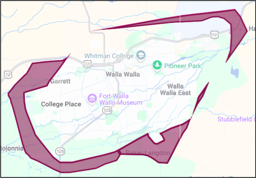
Map of Walla Walla and College Place showing only the areas newly added to the Valley Transit service area. New coverage areas are shaded dark magenta with a matching outline. They include portions of the northwest near Garrett and west of Whitman College; a long northern corridor extending east along U.S. Highway 12 toward the Harbert area; areas along the southern and southwestern edges of College Place and Walla Walla near Mojonnier Road and Baker-Langdon; and narrow new service areas east and southeast of Walla Walla East. Existing service areas are not shaded


Special Services

If you need a bus ride from the airport, call Valley Transit between 8:00 am and 8:00 pm, Monday through Friday, or 10:45 am and 6:00 pm on Saturday. Call us at 509-527-3779, and we’ll send the next Route 1 or East Loop bus to pick you up. This works well with the flights that arrive and depart in the middle of the day. If your flight falls before or after those hours listed above, the bus won’t be available, so you’ll need to take a taxi or use a ride-share service instead.

Special Event

(typically community events with auxiliary public transit services)

Smiling white ghost draped over a red roller skate beneath the dripping words “GHOST TROLLEY.”

Valley Transit will run a “Ghost Trolley” route to tour houses decorated for Halloween. This route will run on October 29th, 30th, and 31st, starting at 6:15 pm, and departing from the Transit Center. Seats are available on a first-come-first-served basis. More information coming soon after the route is fully developed.

Current Short-Term Rider Alerts

None at this time.

Long Term Deviations

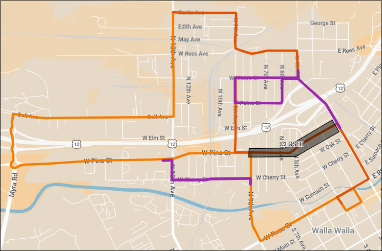
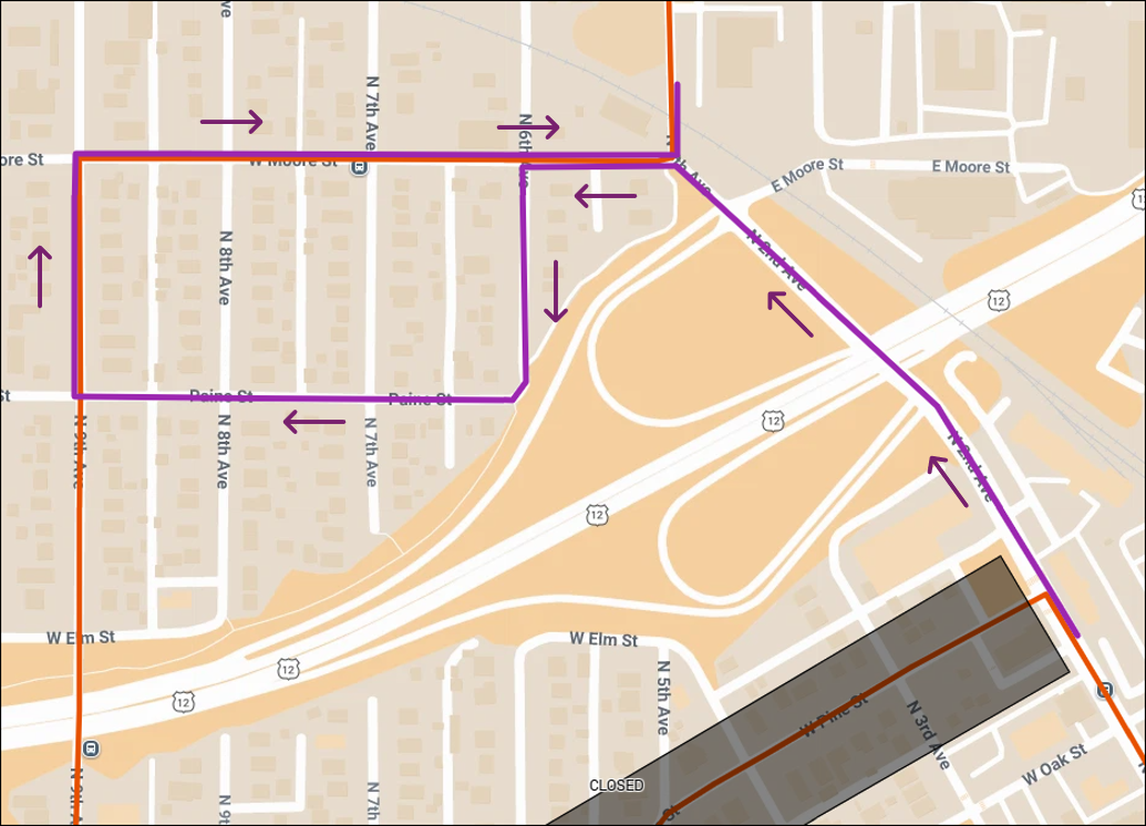
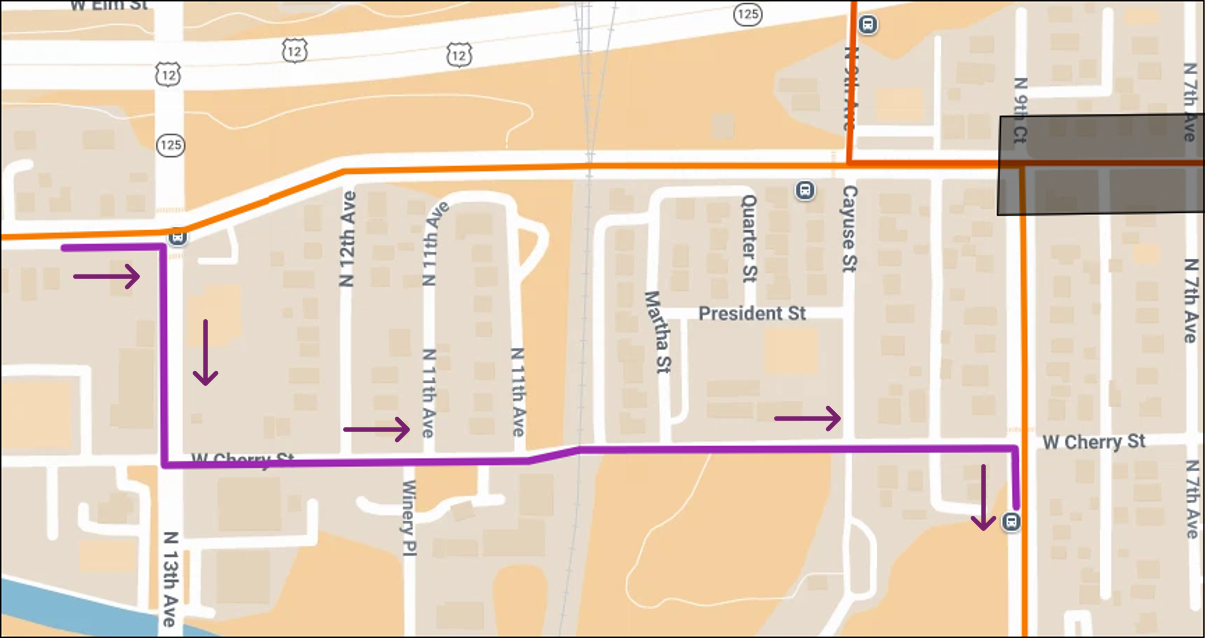
Starting on August 10, 2026, and expected to last through summer of 2027, Route 9 will deviate around a road closure on Pine St between 2nd Ave and 9th Ave. Outbound from the intersection of 2nd St and Pine St, it will continue going north on 2nd St, then turn west on Moore St, then south on 6th Ave, then west on Paine St, then north on 9th Ave to continue on it’s normal route. Inbound, from Pine St, it will turn south on 13th Ave, then east on Cherry St, the south on 9th Ave to continue on it’s normal route. There will be temporary bus stops placed on the west side of 13th between Pine St and Cherry St and on the south side of Cherry St near the Cayuse St intersection.
 
——————–
 
A partir del 10 de agosto de 2026, y con una duración prevista hasta el verano de 2027, la Ruta 9 se desviará para evitar un cierre de vía en Pine St, entre 2nd Ave y 9th Ave. En dirección de salida, desde la intersección de 2nd St y Pine St, continuará hacia el norte por 2nd St, girará al oeste por Moore St, luego al sur por 6th Ave, después al oeste por Paine St y finalmente al norte por 9th Ave para retomar su ruta habitual. En dirección de entrada, desde Pine St, girará al sur por 13th Ave, luego al este por Cherry St y después al sur por 9th Ave para continuar con su recorrido normal. Se habilitarán paradas de autobús provisionales en el lado oeste de 13th Ave, entre Pine St y Cherry St, y en el lado sur de Cherry St, cerca de la intersección con Cayuse St.
Map shows Route 9 deviating around a road closure on Pine St between 2nd Ave and 9th Ave.